Borrowash
Walk and Fly the canal route at Draycott Virtually
Andy Savage at www.derbyphotos.co.uk is a supporter of the DSCT. In April 2021 he produced a virtual walk of the Derby Canal route from Station Road, Borrowash to Ulliker’s Bridge. His video takes a journey through the air from Borrowash Bottom Lock along the canal route to Anglers Lane in Spondon.
The Route
The Borrowash section stretches eastwards from Spondon Bourne, which forms part of the boundary between Derby City and Erewash, to the farm fields beyond the Ock Brook. The brook known as Spondon Bourne was culverted under the Derby Canal shortly before arriving at the River Derwent. The Derby Canal headed east, passing under Ulliker’s Bridge, a farm access bridge which connected Meynall Farm on Nottingham Road to fields south of the canal. It then continued past what are now the backs of the houses on Manor Road before curving south towards the River Derwent, crossing over what is now the Midland Main Line railway. Here there was a lock that lowered the canal, allowing it to pass under Mill Lane, now known as Station Road, which ran between Borrowash and Elvaston. To allow the Midland Counties Railway to run in a straight line when it was built in the 1830s, the Derby Canal was straightened by diverting it via a new lock located to the west of Station Road.
During the building of the new lock and canal sections, workers found the remains of bones and skeletons, estimated to be 80 bodies, along with amulets, brooches, clay pots, Roman coins and various animal bones. This was previously thought to have been the site of a battle between Romans and Britons, but local archaeologists now think it was more likely to have been a burial mound used from the bronze age through to the end of the Anglo Saxon period.
The few artefacts that were not plundered when Bateman, the Victorian archaeologist (b 1821, d 1861), excavated the site are now part of the Bateman Collection at Sheffield Museum. It is possible that when first built, the canal curved towards the river to avoid the burial pit, the pit then having being forgotten about when the railway came through.

Early map showing original route of canal west of Mill Lane, now Station Road.
In 1837, a Lock Keeper’s cottage was built to the north of the new Borrowash Top Lock. There was a pond in its grounds which acted as the lock’s by-wash, with water entering from before, and exiting just after, the lock. Unfortunately, when the canal was infilled, the cottage was bulldozed into the lock chamber and houses built in the cottage grounds.
The Derby Canal continued east to Borrowash Bottom (Shacklecross) Lock. Shacklecross is the area east of Borrowash where the road to Draycott heads along the Roman Road from Derby to Sawley, away from the main Nottingham Road. Below the lock, the Ock Brook was culverted under the Derby Canal before the canal carried on over what are now fields to Derby Road in Draycott.
The map from 1901 shows that an arm went north from the west side of the lock to a flour and corn mill on the side of the Ockbrook. The flour and corn mill was part steam and part water powered, with a weir (15ft drop) on the brook to form a mill pond. Lead mills (for grinding a mineral called white lead or hydrocerussite) were also built around the mill pond, and the flour and corn mill became a blacking mill (for grinding charcoal into dust). A stream from above the mill pond came into the end of the canal arm by the mill house. There was a small wharf and tramway for the mill on the east side of the arm. Later a cotton mill, Borrowash Mill, was added on the west side of the arm. All this has now been buried and the housing estate constructed on the site.


The Restoration Begins
The canal remains filled in from Spondon Bourne to Station Road. Currently the work party volunteers are limited to maintaining the hedges and keeping the ground under control in line with our Land Maintenance Statement, to provide a safe area for walkers and wildlife. This section, given to Derbyshire County Council when the canal was abandoned, was given back to the Trust in 2018. In the 2000’s members of the Trust restored Ulliker’s Bridge.
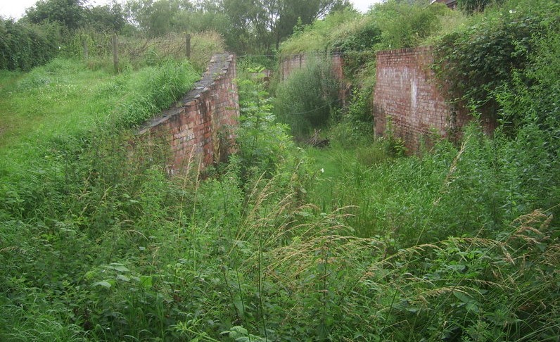
The section from Station Road to Borrowash bottom lock, and the lock chamber itself, was excavated in 1998 with the help of the local builder when they built the houses to the north of the canal. The lock walls were partially restored by local volunteers who repaired the damage done when the lock was filled in and finally dug out. This was one of the IWA’s Waterways Recovery Group (WRG) – the national volunteer canal restoration group – first visits to the site. The section was then left largely untouched long enough for trees and brambles to significantly regrow, and for the lock walls to deteriorate, before it was cleared again in 2018.
A sewer pipe crosses the canal line half way along from Mear Drive to the towpath of the canal. The pipe the follows the towpath to the south side of Borrowash Bottom Lock. From here as the path drops down to the lower level the pipe is now exposed and passes at an angle across the canal bed and the Ock brook to Fosse Close. The Trust’s plan is to have the sewer pipe redirected underground along the north side of the canal. The current cycle path, that now crosses the canal below the lock and heads to the north side, will continue along the new towpath to end of Fosse Close when the canal is restored and the Ock brook culvert constructed.
In the meantime the channel was maintained and the lock repaired. The channel had become overgrown with many Crack Willow trees. A number of Alders remained along the towpath by Station Road and the lock chamber became overgrown with brambles and reeds.
In 2015 regular working parties took the section in hand. A significant effort was made to cut down and remove the trees, such that a very definite canal line could be seen along the majority of the section. This effort continued with regular volunteer working parties, working on both the canal line and lock chamber.
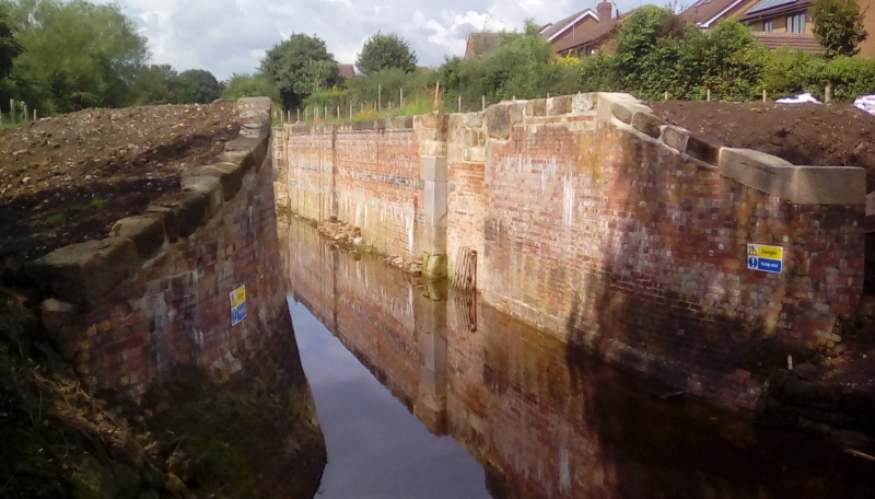
The focus swung onto the lock itself, exposing the missing parts of the lock, checking the chamber wall bricks to ensure that they were stable and the mortar was intact. Work then started to rebuild the lower gate recesses. During 2017 new fencing was erected around the lock, to ensure that people could not fall into the chamber while walking the paths.
Once the walls were restored, our attention turned to the large stone blocks that were missing from the top edge of the lock wall and top ground paddle areas, which has been almost totally dismantled. When the chamber was excavated a number of large blocks were found lying in and around the chamber. They were numbered and catalogued with dimensions so that we could work out where each stone should go.
At this stage, we were approached by the IWA / WRG team to see if we had week long projects that they could help with. So, in 2018 we had a group of 20 volunteers from the WRG, from all over the country and Europe, to help sort out and put in place the large pieces of stone. These included the large anchor stones that support the top of the 4 lock gates and ground paddle areas. With the aid of a spider crane, that could reach both sides of the lock and lift the large blocks, the coping stones and ground paddle areas were rebuilt.
After the first visit our own volunteers also carried out various works on the lock including installing the stop plank channels and surrounding brickwork. Unfortunately, the restoration of the Cottages in Draycott reduced the time that our volunteers could spend on the lock.
We had a second visit by WRG volunteers in 2019 to continue to put the coping stones in place and start to rebuild the wash wall both above and below the lock. The scaffolding around the lower gate wash walls allowed the fitting of the final coping stones to the walls and gate areas, including creating some fake coping stones.
Unfortunately due to the Covid lockdown, we were restricted in what could be done and the next visit could not be arranged until July 2021. At this point the number of volunteers was limited to 12, and our own volunteers couldn’t help out as previously. This was to ensure that the WRG volunteers were in their own protective ‘bubble’. The team managed to complete the north wash wall below the lock, extend the wash walls above the lock and construct the entrance to the by wash. Work was also done to expose the overflow weir on the lower north bank, increase the width of the drainage ditch to allow water out into the Ockbrook and backfill the stonework on top of the lock with soil to create level areas.
A before-and-after picture is available below; use the slider to see how much work has been done on the Borrowash Bottom Lock!
The landscaping and grass seed sowing was later finished by our own volunteers.
In October 2022 work was started by our own volunteers to rebuilding the offside wash wall, by the side of Station Road. This required the stonework to be dug out of the soil that was still left after the original dig-out and removal of brambles so that the volunteers could work safely. The area on top of the off-side bank was planted with a new hedge of hawthorn saplings. In the following years we have also been able to taking advantage of an offer of stones from a Nutbrook Canal bridge at the old Stanton Ironworks.
Future Plans
Our own volunteers continue to work along this section from Station Road to the Ock Brook to keep the vegetation, trees and hedges under control and continue to rebuild the off side wash wall between Station Road and the sewer pipe. Unfortunately, until the sewer pipe is moved we cannot start to rebuild the rest of the wash walls, on both sides, and start building the culvert and canal over the Ock Brook.
Once the work around the Ock Brook culvert is complete, we will look to continue the canal across the field to meet up with the restored section at Draycott with a bridge at Fosse Close and some farm access bridges.
Restoring the section from Station Road to Spondon Bourne, rebuilding Borrowash Top Lock and installing a bridge at Station Road, will connect the two sections together. Rebuilding the culvert and canal line over the Spondon Bourne will take us back to Derby.
A selection of images showing the hard work and effort required for these restorations to become a reality can be seen below.


Once the chamber is complete we will turn our attention to fixing the lock gates and, provided we can get the sewer moved to the north side, bringing back water to the channel. The intention is to fill the section so that it can be used for recreational boating while we await further restoration.
Interested in helping out?
Please feel free to come along to one of our Working Parties in the area, see the Volunteer page for more details.